|
|
| Contents The house The farmyard & malthouse The Norton family A postcard of Hoe The Bylaugh sale The gravel pit Frederick Baker The turbine Mr & Mrs WIlliam Lown Herbert Jarvis Mains water Manor Farm Cottages |
The
house
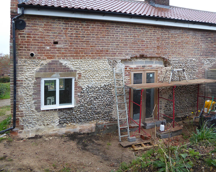
 The farmhouse in 2011. Behind
the brick is a very old timber-framed
building. Manor Farm belonged to the Bylaugh
estate and the porch, double-flue chimneys
and chamfered window frames are all
characteristic of the work done by Norwich
architect Thomas Jeckyll who was employed to
improve farmhouses and farm buildings on the
estate in the 1870s.
In 1693 the Manor of Hoe Harfords alias Colvilles was conveyed from William and Elizabeth Frith to Daniel Farrington. The land is itemised in the conveyance and is situated to the west of the Dereham-to-Holt road in the area known as Stanton Heath. Also described is a 'Freehold Dwelling House'. The manor was later acquired by the Lombe family who owned it at the time of the Inclosure. At the sale of the Lombe's Bylaugh estate, some of the same land was parcelled with Manor Farm, making it possible that the following description in the 1693 conveyance relates to Manor Farm and tells us what the house was like then.  And also one Freehold Dwelling house in Hoe afsd. Containing in Length from the north to the south on the east side thereof 33 ffeet or thereabouts & on the west side thereof together with the scullery built at the North End thereof 38 ffeet 9 inches or thereabouts & in breadth 21 ffeet or thereabouts Containg One Low room called the Little Parlour with a chimney in it One other low room with a chimney in it called the Kitchen one other Low Room being the scullery One wainscott Room and closett called the Kitchen Chamber & Closett over the afsd Parlour Kitchen & Scullery and Two High Loft Chambers and one High Loft Closett over the same Kitchen Chamber & Closett [Courtesy of Norfolk Record Office EVL361/31/9] The farmyard and malthouse  On the Enclosure map of 1814, the old course of the road is shown, running through what is now the farmyard. The farmhouse is shown in pink and the long grey building next to plot 20 is described as a Malt Office. The large field to the right is called Malthouse Piece in the Tithe Assessment (1847). Breweries and malthouses were called 'offices' in contemporary advertisements. Another 'Malt Office' is marked at Hoe Lodge on this same map. [Courtesy of Norfolk Record Office C/Sca/2/243]  The tithe map surveyed in 1847 shows the road's present route as well as the path of the railway then being built (in pink), splitting Malthouse Piece in two. The Tithe Assessment describes Plot 51 as 'Farmhouse Yards Gardens etc', making no reference to the malthouse building, which has been reduced; malting had ceased, presumably. The pond with its sluice and outlet, tailing off to the left to join the Wendling Beck, is another development made since 1814. See the Turbine lower down this page. [Courtesy of Norfolk Record Office BR 276/1/119] The Norton family  In 1851, Samuel Norton was the farmer, having 400 acres and employing sixteen labourers and four boys.  Samuel Norton died in 1855. His widow Maria continued at the farm, describing herself as a 'landed proprietor' in 1861.  Their son Samuel junior, meanwhile, was living somewhere near the church whilst running Manor Farm, taking on the tenancy of Hoe Hall Farm when Thomas Byam Grounds stopped farming it himself.   In 1880, the farm stock, live and dead, was sold by 'the Trustees of Mr. S.J. Norton'. Samuel's will provided for his wife Maria to live on at the farm after his death (in 1855), so perhaps this sale was necessitated by her own death. The newspaper advertisement describes a well-equipped farm. Samuel (jr), his wife Emily and two adult children were living at Spring Farm in 1901. Norfolk Chronicle 25th September 1880  Hazel Fazzani (née Norton) whose
ancestors lived
at Manor Farm,
with her son the
Rev Keith
Fazzani, outside
Hoe Church 2012.
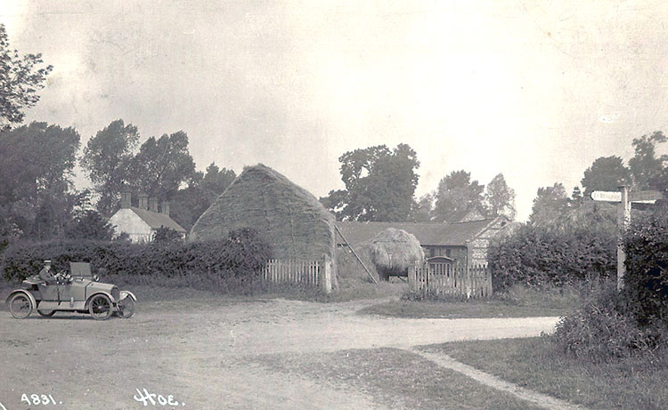
A postcard of Hoe  This lovely postcard shows Manor Farmhouse, the stackyard, and stables beyond. It looks as if the stacks are in the process of being built just after harvest with a laden wagon waiting to be emptied. The roads are not yet tarmaced. The card was posted on 30th August 1915 to London by Vernon Gladden, aged eleven, who was staying with relatives at the Angel pub just up the road. So far, this is the only postcard of Hoe that has come to light. The car is a Humberette. J. J. Wrights, in Dereham, were Humber agents, as well as selling other makes including Quadcycle, one of which is thought to have been the first car owned in Hoe. The Bylaugh sale Sir John Lombe (1731-1817) was Lord of the Manor, lived at Great Melton Hall and owned a very large estate, later centred on Bylaugh Hall, including Manor Farm in Hoe and Home Farm in Worthing. In 1917 when the Bylaugh estate was sold, the catalogue contained the following description: ‘It is rarely that an estate is met with, upon which the houses and buildings are of so universally an excellent and spacious a character. They are not of piecemeal construction, but each set has been designed and built as a whole and is complete with its enclosed yards, sheltered and open to the South, its stalls and feeding passages, and all implement and cart lodges open to the North.’ Manor Farm consisted then of 466 acres and four cottages as well as the large barn at Hoe Brick Kiln. At the auction it was withdrawn at £5,500 but sold later to the tenant, Henry Walter Fox. In the 1911 census Fox was the tenant. He was 37 years old and from Beetley. His wife Edith, from Dereham, was 29 and they had two young children, Dorothy, 2 years, and Edith, 9 months, both born in Hoe. The gravel pit Just to the north-west of Manor Farm house a field was already being dug for gravel in 1917, when the ‘approximate royalty from working … is £45 per annum’. In the 1946 RAF aerial photo below, the extent of the quarry can be seen – it eventually took in almost the whole of the striped field (called Hill Close on earlier maps).  [Copyright Norfolk County Council; photo by RAF 31 January 1946] There is a description of the pit in 'The Geology of the Country around East Dereham' in the Memoirs of the Geological Society published in 1888. Hoe. –– A fine section, in a large gravel-pit on the northern side of the little valley, and west of the railway, nearly three quarters of a mile W.N.W. of the church, showed 21 feet of coarse, well rounded flint-gravel, continuous with, and clearly of the age of, that which overlies the Boulder Clay on the eastern side of the railway-cutting, itself excavated through the gravel. On the eastern side of the railway the gravel becomes less and less thick, until the Boulder Clay comes up to the surface. The gravel in the pit consisted of flints, mostly from 4 to 11 inches in diameter, thickly massed together in a matrix of reddish-brown sand containing some smaller flints. A few lenticular patches of stratified reddish-brown sand occurred in places, also six or seven more or less horizontal but impersistent lines of black manganese-staining; but the whole mass presented an unstratified appearance. Frederick Baker  The farm was
bought by Frederick Baker in 1920 and The farm was
bought by Frederick Baker in 1920 and following his death by Peter and Alice Gow who lived there from 1945. The turbine  The large pond at Manor Farm can be seen on the maps above. The head of water was used to power a horizontal turbine installed near the adjacent barns, driving grinding and chaff cutting machinery inside the buildings. Mr & Mrs William Lown  Mr William Lown, farm
steward, 1946.
 Mrs Emily Lown in the garden of Manor Farm cottages, 1946. Herbert Jarvis  Herbert Jarvis hedging at Manor Farm, 1954. Mains water   October 1969 brought piped water and champagne to Manor Farm. Manor Farm cottages  Aerial view of Manor Farm cottages, Barkers Lane, in the dry summer of 1976. Stanley Mendham's glasshouses grew from a hobby to a nursery business on Swanton Road, Dereham. Sonny and Doris Brown's very productive vegetable garden was next door. The kitchen garden at the right was Mrs Gow's (Manor Farm). Shown as three cottages on the Ordnance Survey 25" sheet of 1882, it is probable that the building is the same as the 'Town House' depicted on the 1773 estate map of Thomas Grounds. See Village page http://www.hoeandworthingarchive.org.uk/village.html Town House.  The roadside end of Manor Farm cottages. The changes in building materials suggest that they were originally single storey with a steeply pitched roof, perhaps thatched, and with a small window in the gable lighting an attic.  In 2021, following the death of Sonny Brown, the cottage was repaired and modernised.  Mod cons at Manor Farm cottages. They probably date from the 1870s when the Bylaugh estate renovated its farms. There would have been a central chimney serving both wash houses (visible in the photo of William Lown, above). The outer doors are to the closets – a small brick archway is visible at the back right-hand corner at ground level, presumably provided to enable the earth closets to be emptied. |