Hoe and Worthing Archive: The Village


Faden Worthing

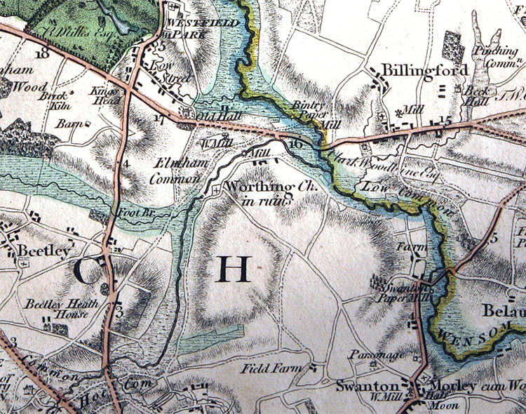
Faden's map of Norfolk of 1797 shows Worthing, its church 'in ruins', nestled on the north-facing slope of the Wensum valley.
To the west the boundary is also formed by water – the stream known variously as the Whitewater, the Blackwater, and the Scarning River. The prominent hill to the south became Swanton Morley airfield in 1940 and remains in military hands, the road running south-east from the church closed since then.

[Reproduced by courtesy of Andrew Mcnair.]


History of the village


Until the enclosures, Worthing was a green village running along a road bordering the low-lying common near Worthing Mill. In the early nineteenth century the thinly-scattered green frontage was 650 metres long. This location was probably determined by the crossing point of the Scarning River at Worthing Mill, but the existing road junction at the approach to the river was almost certainly planned at the enclosures; archaeological fieldwork in the gaps along the edge of the green has not so far produced any evidence for medieval occupation.


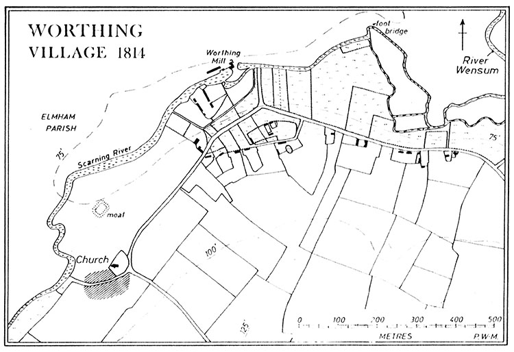
The church is situated on the side of the valley further upstream, well separated from the existing village. In the nineteenth century the road made a detour around the church, but this has since been straightened. Although there is no archaeological evidence for occupation between the village and the church, Thetford ware and medieval coarse and glazed wares have been collected on the south side of the latter.


The present village is not on the site of the medieval one, which was probably to the south and south-east of the church. It was not mentioned in the Domesday survey and an eleventh–century date for the first village seems likely on archaeological grounds.


A small moated site lies in the meadows at the bend in the river north of the church. A raised rectangular platform in the north-east corner may perhaps represent the manor house. The presence of the moat here close to the church might explain why this river meadow was the only one which was not a part of the common in the eighteenth century.


manor map


map


The piece of land adjacent to the mill was isolated from the common by a small leet, and this was also private land.


Somewhere near the village is the line of the Billingford to Denver Roman road. At present there is a gap in the known line of the road in Worthing parish. There are no features on the early nineteenth-century enclosure map which can be related to the road, which was probably abandoned in favour of the present valley-side route at an early stage. It appears that the village was founded only 250 metres away from the line of the Roman road, although the road itself was probably already disused by that date.


Roman map

Roman roads in Norfolk and the sites of the Roman finds in Worthing.


[From 'A Roman Decorated Helmet and other Objects fronm Norfolk' in The Journal of Roman Studies, Toynbee & Clarke, 1948]


Place-name spellings

Extract from Dr O.K. Schram’s notes: 1209 Wrthing; 1228 Worthing.


[Extract from East Anglian Archaeology Report No. 10, 'Village Sites in Launditch Hundred 1980', Peter Wade-Martins ( L942.61A Dereham Library)
Reproduced by courtesy of Dr Peter Wade-Martins]


An Elizabethan court case


Warner versus Morley

In the National Archive at the Public Record Office is the account of a case at the Court of Chancery held in 1571. The complainant was a farmer called Thomas Warner (of Hoo) and the defendants Sir Henry Parker, Lord Morley, and his steward Robert Constable. Morley was lord of the manor of Swanton Morley & Worthing from whom Warner had leased land in Worthing. A dispute arose because of unpaid rent. The system of copyhold leases required the tenant to pay a ‘fine’ to the lord for admission to the tenancy as well as rent. A copy of the lease was then given to the tenant. A lease could be sold to another person who had then to pay the fine for admission.

The substance of the court case was that Warner had been refused admission to forty-seven acres land he had bought. Robert Constable, the steward, refused to give him a lease despite Warner having offered to pay.

Morley’s defence was that Warner was buying up land in the parish, selling the houses off with a small amount of land and converting the rest from arable to pasture, presumably for sheep. According to Morley this was to the detriment of the ‘many labouring personnes’ formerly employed in farming, leading to ‘the decaye of husbandrie’. It may also have deprived Morley of income – he alleged that ‘the said mannor of Swanton Morley and Worthing is an ayncyent mannor and Lordeshipp and the contynuance thereof consysted chiefly in the diversitie and nomber of tenantes’. At various dates following the depopulation of the countryside caused by the Black Death in the fourteenth century, acts of parliament had sought to prevent the conversion of arable land to sheep pasture, for the very reasons Morley employs.

In the resolution of the case Warner agreed that he would ‘so use and converte the same in tyllyng as the said fortie seven acres have bene used to be tylled and sowen’, and it was also stipulated that ‘thomage of the said mannor of Worthing (ie, the homage, or the lord’s servants in the village) shall upon their othes treade owte sever and bounde the said seven and fortie acres and a halfe in suffycyent order as the same may be distinctly knowen by yt self to the said lorde … from other landes eyther ffree or copie holde that the said complainant (Warner) hathe, and that no parcell of the said lands to be severed or plucked awaye from the said tenement …’. And so Warner, having paid his dues, got his lease.

The court record also mentions that Morley as lord of the manor had a right of foldcourse or shackage on some of the parish lands. This entitled him at certain times to the grazing of his tenants’ sheep and their manure which was of benefit to the land. It may be that the higher land sometimes known as Worthing Brecks, between the church and the airfield, with its poor stony soil, was the site.


The National Archives reference C 78/37/23


Worthing bridge

worthing bridge


Bureaucracy was alive and well in October 1903, as reported in the local newspaper.


ford


This incident had happened a month earlier.


bridge


The bridge when it was new.


village story


village story text

In August 1966 the local newspaper had just about written Worthing off – no girls of 'marriageable age'!


The Norfolk Heritage Explorer website lists all the known antiquities in the village:
http://www.heritage.norfolk.gov.uk/record-details?TNF276-Parish-Summary-Hoe-%28Parish-Summary%29